
Make a donation
Sichuan topographic map
Click on the map to display elevation.
Make a donation
Sichuan
Due to great differences in terrain, the climate of the province is highly variable. In general, it has strong monsoonal influences, with rainfall heavily concentrated in the summer. Under the Köppen climate classification, the Sichuan Basin (including Chengdu) in the eastern half of the province experiences a humid subtropical climate (Köppen Cwa or Cfa), with long, hot, wet summers and short, mild to cool, dry, and cloudy winters. Consequently, it has China's lowest sunshine totals. The western region has mountainous areas producing a cooler but sunnier climate. Having cool to very cold winters and mild summers, temperatures generally decrease with greater elevation. However, due to its high altitude and its inland location, many areas such as Garze County and Zoige County in Sichuan exhibit a subarctic climate (Köppen Dwc)- featuring extremely cold winters down to −30 °C and even cold summer nights. The region is geologically active with landslides and earthquakes. Average elevation ranges from 2,000 to 3,500 meters; average temperatures range from 0 to 15 °C. The southern part of the province, including Panzhihua and Xichang, has a sunny climate with short, very mild winters and very warm to hot summers.
Make a donation
About this map
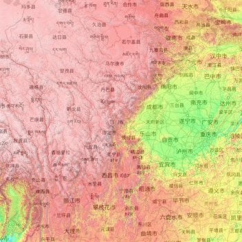
Name: Sichuan topographic map, elevation, terrain.
Location: Sichuan, China (26.04817 97.34738 34.31471 108.54267)
Average elevation: 2,522 m
Minimum elevation: 140 m
Maximum elevation: 6,536 m
Make a donation
Other topographic maps
Click on a map to view its topography, its elevation and its terrain.
Zhangye Danxia National Geological Park
China > Gansu > Sunan Yugur Autonomous County
The core area of the park, Linze Danxia Scenic Area, is located 30 kilometres (19 mi) west of downtown Zhangye and 20 kilometres (12 mi) south of the seat of Linze County. It is the most developed and most visited part of the park. A second scenic area, Binggou (冰沟), located on the north bank of Liyuan…
Average elevation: 1,759 m
Make a donation
Chongqing Yunyang Longgang National Geopark
China > Chongqing > Yunyang County
Average elevation: 832 m
Chongqing
The central urban area of Chongqing, or Chongqing proper, is a city of unique features. Built on mountains and partially surrounded by the Yangtze and Jialing rivers, it is known as a "mountain city" and a "city on rivers". The night scene of the city is very illuminated, with millions of lights and their…
Average elevation: 318 m
Mischief Reef
China > Hainan Province > Sansha
Mischief Reef, also known as Panganiban Reef (Filipino: Bahura ng Panganiban; Vietnamese: Đá Vành Khăn; Mandarin Chinese: 美濟礁/美济礁; pinyin: Měijì Jiāo; lit. 'Meiji Reef'), is a low tide elevation (LTE) reef/atoll surrounding a large lagoon in the SE of Dangerous Ground in the east of the…
Average elevation: 0 m
Make a donation
Subi Reef
China > Hainan Province > Nansha District
On 12 July 2016, the UNCLOS special arbitral tribunal in the Philippines v. China case confirmed that Subi Reef is, or in its natural condition was, exposed at low tide and submerged at high tide and is, accordingly a low-tide elevation that does not generate entitlement to a territorial sea, exclusive…
Average elevation: 0 m
Shanghai
The golden age of Shanghai began with its elevation to municipality after it was separated from Jiangsu on 7 July 1927. This new Chinese municipality covered an area of 494.69 km2 (191.0 sq mi), including the modern-day districts of Baoshan, Yangpu, Zhabei, Nanshi, and Pudong, but excluded the foreign…
Average elevation: 5 m
Beijing
Beijing is situated at the northern tip of the roughly triangular North China Plain, which opens to the south and east of the city. Mountains to the north, northwest and west shield the city and northern China's agricultural heartland from the encroaching desert steppes. The northwestern part of the…
Average elevation: 47 m
Make a donation
Make a donation
Make a donation
Make a donation
Shigatse
China > Tibet > Chengdong Subdistrict
Shigatse Peace Airport began operations on 30 October 2010 after an Airbus A319 landed safely, making it Tibet's fifth commercial airport. It is located 43 kilometres from Samzhubzê District at Jangdam Township at an elevation of 3,782 metres. The airport will be capable of supporting 230,000 passengers…
Average elevation: 4,055 m
Make a donation