Geolocate

Mahlerovy sady topographic map

Interactive map

Click on the map to display elevation.

About this map

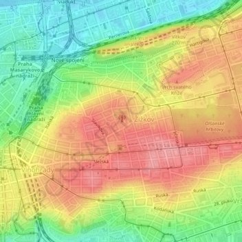
Name: Mahlerovy sady topographic map, elevation, terrain.

Location: Mahlerovy sady, Žižkov, Prague, Czechia (50.07993 14.44974 50.08153 14.45237)

Average elevation: 240 m

Minimum elevation: 188 m

Maximum elevation: 286 m

Other topographic maps

Click on a map to view its topography, its elevation and its terrain.

Jewish quarter

Czechia > Prague > Prague

Jewish quarter, Praha 1, Prague, Czechia

Average elevation: 216 m

Prague

Czechia > Prague > Prague

Prague, Czechia

Average elevation: 300 m

Slivenec

Czechia > Prague > Prague

Slivenec, Prague, 154 00, Czechia

Average elevation: 326 m

Praha 1

Czechia > Prague > Prague

Praha 1, Prague, Czechia

Average elevation: 229 m

New Town

Czechia > Prague > Prague

New Town, Prague, Czechia

Average elevation: 215 m

Troja

Czechia > Prague > Prague

Troja, Prague, okres Hlavní město Praha, Hlavní město Praha, Prague, 17100, Czechia

Average elevation: 237 m

Old Town

Czechia > Prague > Prague

Old Town, Prague, okres Hlavní město Praha, Hlavní město Praha, Prague, Czechia

Average elevation: 216 m

Černý Most

Czechia > Prague > Prague

Černý Most, Prague, okres Hlavní město Praha, Hlavní město Praha, Prague, Czechia

Average elevation: 252 m