
Thank you for supporting this site ❤️
Make a donation
Make a donation
Morayur topographic map
Click on the map to display elevation.
Thank you for supporting this site ❤️
Make a donation
Make a donation
About this map
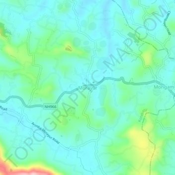
Name: Morayur topographic map, elevation, terrain.
Location: Morayur, Kondotty, Malappuram, Kerala, 673642, India (11.11378 75.99665 11.15378 76.03665)
Average elevation: 65 m
Minimum elevation: 21 m
Maximum elevation: 234 m
Thank you for supporting this site ❤️
Make a donation
Make a donation
Other topographic maps
Click on a map to view its topography, its elevation and its terrain.