
Bonau topographic map
Interactive map
Click on the map to display elevation.
About this map
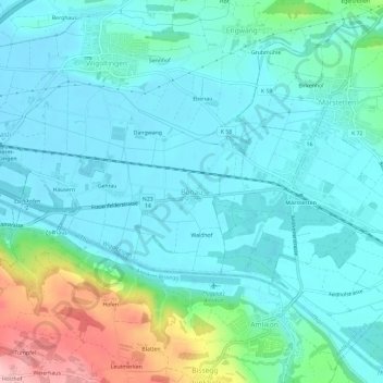
Name: Bonau topographic map, elevation, terrain.
Location: Bonau, Wigoltingen, Bezirk Weinfelden, Thurgau, 8556, Schweiz (47.56322 9.02523 47.60322 9.06523)
Average elevation: 441 m
Minimum elevation: 407 m
Maximum elevation: 574 m
Other topographic maps
Click on a map to view its topography, its elevation and its terrain.
Märstetten
Schweiz > Thurgau > Bezirk Weinfelden
Märstetten, Bezirk Weinfelden, Thurgau, 8560, Schweiz
Average elevation: 449 m
Weinfelden
Schweiz > Thurgau > Bezirk Weinfelden
Weinfelden, Bezirk Weinfelden, Thurgau, 8570, Schweiz
Average elevation: 494 m