
Wetter (Ruhr) topographic map
Interactive map
Click on the map to display elevation.
About this map
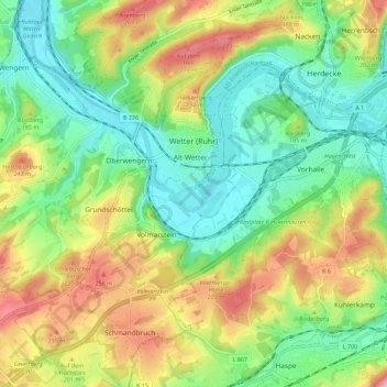
Name: Wetter (Ruhr) topographic map, elevation, terrain.
Average elevation: 161 m
Minimum elevation: 77 m
Maximum elevation: 301 m
Other topographic maps
Click on a map to view its topography, its elevation and its terrain.
Scherpenberg
Duitsland > Noordrijn-Westfalen > Ennepe-Ruhr-Kreis > Sprockhövel
Scherpenberg, Sprockhövel, Ennepe-Ruhr-Kreis, Noordrijn-Westfalen, 42279, Duitsland
Average elevation: 268 m
Scheven
Duitsland > Noordrijn-Westfalen > Ennepe-Ruhr-Kreis > Sprockhövel
Scheven, Sprockhövel, Ennepe-Ruhr-Kreis, Noordrijn-Westfalen, 45549, Duitsland
Average elevation: 232 m
Arenberg
Duitsland > Noordrijn-Westfalen > Ennepe-Ruhr-Kreis > Witten
Arenberg, Witten, Ennepe-Ruhr-Kreis, Noordrijn-Westfalen, 58453, Duitsland
Average elevation: 194 m