
Central Lake Township topographic map
Interactive map
Click on the map to display elevation.
About this map
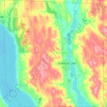
Name: Central Lake Township topographic map, elevation, terrain.
Average elevation: 226 m
Minimum elevation: 176 m
Maximum elevation: 293 m
Other topographic maps
Click on a map to view its topography, its elevation and its terrain.
Torch Lake
United States > Michigan > Antrim County
Torch Lake, Torch Lake Township, Antrim County, Michigan, 49627, United States
Average elevation: 180 m
Jordan Township
United States > Michigan > Antrim County
Jordan Township, Antrim County, Michigan, United States
Average elevation: 268 m
Bellaire
United States > Michigan > Antrim County
Bellaire, Kearney Township, Antrim County, Michigan, 49615, United States
Average elevation: 198 m
Ellsworth
United States > Michigan > Antrim County > Ellsworth
Ellsworth, Banks Township, Antrim County, Michigan, United States
Average elevation: 220 m