
Make a donation
Kareeberg Local Municipality topographic map
Click on the map to display elevation.
Make a donation
About this map
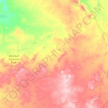
Name: Kareeberg Local Municipality topographic map, elevation, terrain.
Average elevation: 1,145 m
Minimum elevation: 837 m
Maximum elevation: 1,656 m
Make a donation
Other topographic maps
Click on a map to view its topography, its elevation and its terrain.
Loxton
South Africa > Northern Cape > Pixley ka Seme District Municipality > Ubuntu Local Municipality
Average elevation: 1,370 m
Schmidtsdrif
South Africa > Northern Cape > Pixley ka Seme District Municipality > Siyancuma Local Municipality
Average elevation: 1,015 m
MeerKAT
South Africa > Northern Cape > Pixley ka Seme District Municipality > Kareeberg Local Municipality
Average elevation: 1,050 m
Britstown
South Africa > Northern Cape > Pixley ka Seme District Municipality > Emthanjeni Local Municipality
Average elevation: 1,130 m
Make a donation
Van Wyksvlei
South Africa > Northern Cape > Pixley ka Seme District Municipality > Kareeberg Local Municipality
Average elevation: 974 m
MeerKAT
South Africa > Northern Cape > Pixley ka Seme District Municipality > Kareeberg Local Municipality
Average elevation: 1,051 m
Norvalspont
South Africa > Northern Cape > Pixley ka Seme District Municipality > Umsobomvu Local Municipality
Average elevation: 1,236 m
Vanwyksvlei Dam
South Africa > Northern Cape > Pixley ka Seme District Municipality > Kareeberg Local Municipality
Average elevation: 968 m
Make a donation
Campbell
South Africa > Northern Cape > Pixley ka Seme District Municipality > Siyancuma Local Municipality
Average elevation: 1,266 m
Richmond
South Africa > Northern Cape > Pixley ka Seme District Municipality > Ubuntu Local Municipality
Average elevation: 1,453 m
Griekwastad
South Africa > Northern Cape > Pixley ka Seme District Municipality > Siyancuma Local Municipality
Average elevation: 1,337 m
Oorlogspoort
South Africa > Northern Cape > Pixley ka Seme District Municipality > Umsobomvu Local Municipality
Average elevation: 1,285 m
Make a donation