
Douar Zatima topographic map
Interactive map
Click on the map to display elevation.
About this map
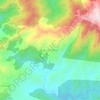
Name: Douar Zatima topographic map, elevation, terrain.
Location: Douar Zatima, Beni Mileuk, Daïra Damous, Tipaza, Algérie (36.43873 1.72095 36.47873 1.76095)
Average elevation: 631 m
Minimum elevation: 370 m
Maximum elevation: 1,079 m
Other topographic maps
Click on a map to view its topography, its elevation and its terrain.
Damous
Algérie > Tipaza > Daïra Damous
Damous, Daïra Damous, Tipaza, 42014, Algérie
Average elevation: 350 m