
Thank you for supporting this site ❤️
Make a donation
Make a donation
Wiener Neustadt topographic map
Click on the map to display elevation.
Thank you for supporting this site ❤️
Make a donation
Make a donation
About this map
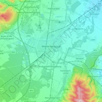
Name: Wiener Neustadt topographic map, elevation, terrain.
Location: Wiener Neustadt, Lower Austria, Austria (47.74268 16.14651 47.87157 16.28590)
Average elevation: 299 m
Minimum elevation: 232 m
Maximum elevation: 621 m
Thank you for supporting this site ❤️
Make a donation
Make a donation
Other topographic maps
Click on a map to view its topography, its elevation and its terrain.
Lahnberg
Austria > Lower Austria > Bezirk Neunkirchen > Schwarzau im Gebirge
Average elevation: 1,213 m