
Saint-Just-de-Bélengard topographic map
Interactive map
Click on the map to display elevation.
About this map
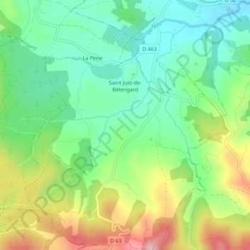
Name: Saint-Just-de-Bélengard topographic map, elevation, terrain.
Average elevation: 364 m
Minimum elevation: 282 m
Maximum elevation: 509 m
Other topographic maps
Click on a map to view its topography, its elevation and its terrain.
La Pene
France > Occitanie > Aude > Escueillens-et-Saint-Just-de-Bélengard > Escueillens
La Pene, Saint-Just-de-Bélengard, Escueillens, Escueillens-et-Saint-Just-de-Bélengard, Limoux, Aude, Occitanie, France métropolitaine, 11240, France
Average elevation: 348 m