
Make a donation
Lehrbach topographic map
Click on the map to display elevation.
Make a donation
Lehrbach
Die Statistisch-topographisch-historische Beschreibung des Großherzogthums Hessen berichtet 1830 über Lehrbach.
Make a donation
About this map
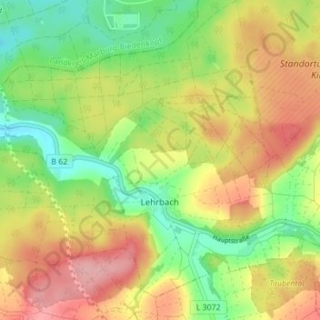
Name: Lehrbach topographic map, elevation, terrain.
Location: Lehrbach, Kirtorf, Vogelsbergkreis, Hessen, Deutschland (50.76376 9.01511 50.80130 9.08419)
Average elevation: 274 m
Minimum elevation: 217 m
Maximum elevation: 335 m
Make a donation
Other topographic maps
Click on a map to view its topography, its elevation and its terrain.
Hoherodskopf
Deutschland > Hessen > Vogelsbergkreis > Breungeshain
Vom Gipfel des Hoherodskopfs bietet sich Fernsicht bis in das Rhein-Main-Gebiet und zum Taunus. Auf dem Westhang verläuft Hessens längster Skilift mit 1,2 km Länge, ein weiterer auf dem Südhang. Mehrere Loipen werden gespurt, auf der Ostseite befindet sich sogar eine mit Flutlicht (für Diagonal- und…
Average elevation: 680 m
Merlau
Deutschland > Hessen > Vogelsbergkreis
In der Topographia Germaniae von Matthäus Merian von 1646/1655 wird Merlau wie folgt beschrieben.
Average elevation: 289 m
Make a donation
Make a donation
Brauerschwend
Deutschland > Hessen > Vogelsbergkreis > Brauerschwend
Die Statistisch-topographisch-historische Beschreibung des Großherzogthums Hessen berichtet 1830 über Mainzlar.
Average elevation: 362 m
Ilbeshausen
Deutschland > Hessen > Vogelsbergkreis > Grebenhain > Ilbeshausen
Average elevation: 478 m
Make a donation
Nieder-Ofleiden
Deutschland > Hessen > Vogelsbergkreis > Homberg (Ohm) > Nieder-Ofleiden
Average elevation: 236 m
Make a donation
Blockfelder am Taufstein
Deutschland > Hessen > Vogelsbergkreis > Breungeshain
Der Taufstein ist mit 773 m ü. NHN der höchste Gipfel im Vogelsberg. Er befindet sich bei Breungeshain im hessischen Vogelsbergkreis. Trotz einer beachtlichen Dominanz von 43 km und einer Schartenhöhe von 406 m fällt der Taufstein als Einzelberg kaum auf, da er aus der Gesamterhebung des Vogelsbergs nur…
Average elevation: 705 m