
Thank you for supporting this site ❤️
Make a donation
Make a donation
Bobadela topographic map
Click on the map to display elevation.
Thank you for supporting this site ❤️
Make a donation
Make a donation
Bobadela
The Chapel of São Lourenço, erected in 1742, is located in the higher altitudes of the settlement, and since this period has fallen on a bad state of conservation.
Thank you for supporting this site ❤️
Make a donation
Make a donation
About this map
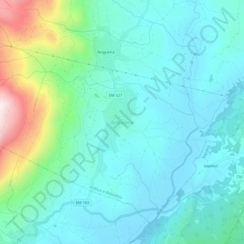
Name: Bobadela topographic map, elevation, terrain.
Location: Bobadela, Boticas, Vila Real, Portugal (41.71104 -7.63805 41.75104 -7.59805)
Average elevation: 633 m
Minimum elevation: 506 m
Maximum elevation: 1,126 m
Thank you for supporting this site ❤️
Make a donation
Make a donation
Other topographic maps
Click on a map to view its topography, its elevation and its terrain.