
Newton Township topographic map
Interactive map
Click on the map to display elevation.
About this map
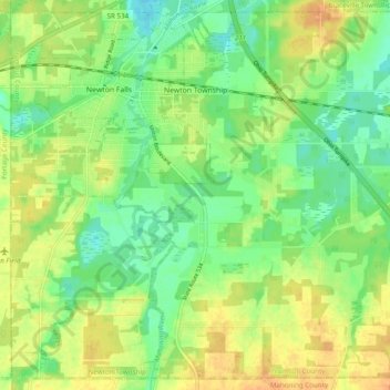
Name: Newton Township topographic map, elevation, terrain.
Location: Newton Township, Trumbull County, Ohio, United States (41.13419 -81.00276 41.20299 -80.90567)
Average elevation: 285 m
Minimum elevation: 269 m
Maximum elevation: 301 m
Other topographic maps
Click on a map to view its topography, its elevation and its terrain.
Girard
United States > Ohio > Trumbull County > Liberty Township
Girard, Liberty Township, Trumbull County, Ohio, 44420, United States
Average elevation: 309 m
Hubbard Township
United States > Ohio > Trumbull County
Hubbard Township, Trumbull County, Ohio, United States
Average elevation: 318 m