
San Jerónimo Tecuanipan topographic map
Interactive map
Click on the map to display elevation.
About this map
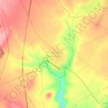
Name: San Jerónimo Tecuanipan topographic map, elevation, terrain.
Location: San Jerónimo Tecuanipan, Puebla, México (18.99556 -98.42139 19.03556 -98.38139)
Average elevation: 2,155 m
Minimum elevation: 2,076 m
Maximum elevation: 2,196 m
Other topographic maps
Click on a map to view its topography, its elevation and its terrain.
Tecajete
México > Puebla > San Jerónimo Tecuanipan > San Miguel Papaxtla
Tecajete, San Miguel Papaxtla, San Jerónimo Tecuanipan, Puebla, México
Average elevation: 2,264 m