
Thank you for supporting this site ❤️
Make a donation
Make a donation
Jurong topographic map
Click on the map to display elevation.
Thank you for supporting this site ❤️
Make a donation
Make a donation
About this map
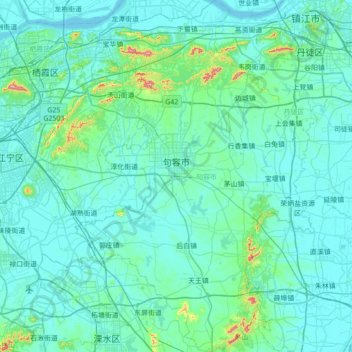
Name: Jurong topographic map, elevation, terrain.
Location: Jurong, Zhenjiang, Jiangsu, 212400, China (31.62704 118.96212 32.21811 119.37969)
Average elevation: 32 m
Minimum elevation: 0 m
Maximum elevation: 421 m
Thank you for supporting this site ❤️
Make a donation
Make a donation
Other topographic maps
Click on a map to view its topography, its elevation and its terrain.
Nanjing
There are mainly two types of soil in Nanjing: zonal soil and cultivated soil. The zonal soil is yellow-brown soil in the northern and central areas of Nanjing, and red soil in the southern part of the border with Anhui. The cultivated soil formed by man-made farming is mainly paddy soil, and there are some…
Average elevation: 25 m