
Thank you for supporting this site ❤️
Make a donation
Make a donation
Huntington Beach topographic map
Click on the map to display elevation.
Thank you for supporting this site ❤️
Make a donation
Make a donation
About this map
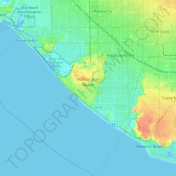
Name: Huntington Beach topographic map, elevation, terrain.
Location: Huntington Beach, Orange County, California, United States (33.58852 -118.11842 33.75621 -117.94038)
Average elevation: 7 m
Minimum elevation: -4 m
Maximum elevation: 37 m
Thank you for supporting this site ❤️
Make a donation
Make a donation
Other topographic maps
Click on a map to view its topography, its elevation and its terrain.