
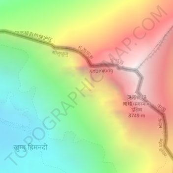
Himalayas topographic map
Interactive map
Click on the map to display elevation.
About this map
Name: Himalayas topographic map, elevation, terrain.
Average elevation: 7,555 m
Minimum elevation: 6,448 m
Maximum elevation: 8,849 m
The Himalayas, or Himalaya (/ˌhɪməˈleɪ.ə, hɪˈmɑːləjə/; Sanskrit: [ɦɪmaːlɐjɐ]; from Sanskrit himá 'snow, frost', and ā-laya 'dwelling, abode'), is a mountain range in Asia, separating the plains of the Indian subcontinent from the Tibetan Plateau. The range has some of the Earth's highest peaks, including the very highest, Mount Everest; over 100 peaks exceeding elevations of 7,200 m (23,600 ft) above sea level lie in the Himalayas.
Other topographic maps
Click on a map to view its topography, its elevation and its terrain.
Mount Everest
Nepal > Koshi Province > Solukhumbu
Mount Everest, Khumbupasanglahmu, Solukhumbu, Koshi Province, Nepal
Average elevation: 7,847 m
Phaplu
Nepal > Koshi Province > Solukhumbu
Phaplu, Solududhkunda, Solukhumbu, Koshi Province, 50600, Nepal
Average elevation: 2,518 m
Tingla
Nepal > Koshi Province > Solukhumbu
Tingla, Nechasalyan-06, Nechasalyan, Solukhumbu, Koshi Province, Nepal
Average elevation: 1,843 m
Lukla
Nepal > Koshi Province > Solukhumbu
Lukla, Khumbupasanglahmu, Solukhumbu, Koshi Province, Nepal
Average elevation: 2,996 m