Geolocate

Mirpur topographic map

Interactive map

Click on the map to display elevation.

About this map

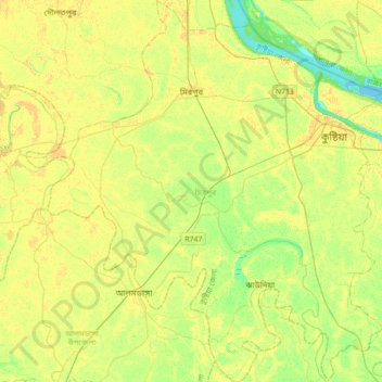
Name: Mirpur topographic map, elevation, terrain.

Location: Mirpur, Kushtia District, Khulna Division, Bangladesh (23.69045 88.86478 24.01270 89.17646)

Average elevation: 13 m

Minimum elevation: 1 m

Maximum elevation: 21 m

Other topographic maps

Click on a map to view its topography, its elevation and its terrain.

Khesra

Bangladesh > Khulna Division > Tala Upazila

Average elevation: 2 m

Mathabhanga River

Bangladesh > Khulna Division

Average elevation: 18 m

Auria

Bangladesh > Khulna Division > Auria

Average elevation: 6 m

Daulatpur

Bangladesh > Khulna Division > Daulatpur

Average elevation: 4 m

Diara

Bangladesh > Khulna Division > Diara

Average elevation: 7 m

Bhatpara

Bangladesh > Khulna Division > Bhatpara

Average elevation: 16 m

Jhenaidah

Bangladesh > Khulna Division > Jhenaidah

Average elevation: 9 m