
St. Albans topographic map
Interactive map
Click on the map to display elevation.
About this map
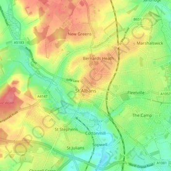
Name: St. Albans topographic map, elevation, terrain.
Location: St. Albans, St Albans, Hertfordshire, Inglaterra, Reino Unido (51.72913 -0.37529 51.78007 -0.29102)
Average elevation: 103 m
Minimum elevation: 69 m
Maximum elevation: 141 m
Other topographic maps
Click on a map to view its topography, its elevation and its terrain.
Barley
Reino Unido > Inglaterra > Hertfordshire > North Hertfordshire > Barley
Barley, North Hertfordshire, Hertfordshire, Inglaterra, Reino Unido
Average elevation: 103 m