
Make a donation
Zumpango topographic map
Click on the map to display elevation.
Make a donation
Zumpango
About half of the territory is flat, mostly in the south with hills and small mountains in the north. The highest elevation is the Cerro del Zitlaltepec at 1650 meters above sea level. The main surface water is Lake Zumpango, which extends over 2,000 hectares. There are also some seasonal streams, the Gran Canal and other tunnels dug to drain the Valley of Mexico.
Make a donation
About this map
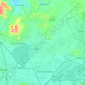
Name: Zumpango topographic map, elevation, terrain.
Location: Zumpango, State of Mexico, Mexico (19.72170 -99.19358 19.90413 -98.97020)
Average elevation: 2,276 m
Minimum elevation: 2,198 m
Maximum elevation: 2,703 m
Make a donation
Other topographic maps
Click on a map to view its topography, its elevation and its terrain.
Texcoco de Mora
Mexico > State of Mexico > Texcoco
Tescoco lies about 25 km east of the centre of Mexico City. Major elevations in the municipality include the Tlaloc Mountain (4,500 meters) the Tetzcutzinco, Moyotepec and Tecuachacho. Most elevations are named after the major community to be found on them. There are also a number of small canyons. Part of the…
Average elevation: 2,262 m