
Seebach topographic map
Interactive map
Click on the map to display elevation.
About this map
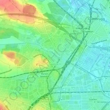
Name: Seebach topographic map, elevation, terrain.
Location: Seebach, Kreis 11, Zürich, Bezirk Zürich, Zürich, 8052, Schweiz (47.41280 8.51957 47.43289 8.56322)
Average elevation: 442 m
Minimum elevation: 420 m
Maximum elevation: 487 m
Other topographic maps
Click on a map to view its topography, its elevation and its terrain.
Witikon
Schweiz > Zürich > Bezirk Zürich > Zürich
Witikon, Kreis 7, Zürich, Bezirk Zürich, Zürich, 8053, Schweiz
Average elevation: 584 m
Chäferberg
Schweiz > Zürich > Bezirk Zürich > Zürich
Chäferberg, Zürich, Bezirk Zürich, Zürich, 8093, Schweiz
Average elevation: 479 m
Oberstrass
Schweiz > Zürich > Bezirk Zürich > Zürich
Oberstrass, Kreis 6, Zürich, Bezirk Zürich, Zürich, Schweiz
Average elevation: 511 m
Altstetten
Schweiz > Zürich > Bezirk Zürich > Zürich
Altstetten, Kreis 9, Zürich, Bezirk Zürich, Zürich, Schweiz
Average elevation: 445 m