
Koshi River topographic map
Interactive map
Click on the map to display elevation.
About this map
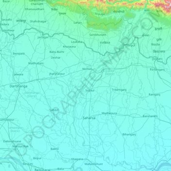
Name: Koshi River topographic map, elevation, terrain.
Location: Koshi River, Beldaur, Khagaria, Bihar, 813210, India (25.40379 86.44059 25.84319 87.26669)
Average elevation: 39 m
Minimum elevation: 24 m
Maximum elevation: 287 m
The Sagarmatha National Park encompasses the upper catchments of the Dudh Koshi River system. The park covers an area of 1,148 km2 (443 sq mi) and ranges in elevation from 2,845 m (9,334 ft) to 8,848 m (29,029 ft) at the summit of Mount Everest. Established in 1976 the park was declared a UNESCO World Heritage Site in 1979. The landscape in the park is rugged consisting of mountain peaks, glaciers, rivers, lakes, forests, alpine scrubs and meadows. The forests comprise stands of oak, blue pine, fir, birch, juniper and rhododendron. The park provides habitat for snow leopards, red pandas, musk deer, Himalayan tahrs, and 208 bird species including impeyan pheasant, bearded vulture, snow cock, and the yellow-billed chough.
Other topographic maps
Click on a map to view its topography, its elevation and its terrain.
Kishanganj
India > Bihar > Kishanganj
Kishanganj, Kishanganj District, Bihar, 855107, India
Average elevation: 48 m
Purnia
India > Bihar > Purnia East
Purnia, Purnia East, Purnia District, Bihar, 854301, India
Average elevation: 38 m
Sheikhpura
India > Bihar > Sheikhpura
Sheikhpura, Sheikhpura District, Bihar, 803109, India
Average elevation: 49 m
Sonbhadra
India > Bihar > Sonbhadra Banshi Suryapur
Sonbhadra, Sonbhadra Banshi Suryapur, Arwal District, Bihar, 824120, India
Average elevation: 74 m
10
India > Bihar > Patna Rural > Patna
10, Patna, Patna Rural, Patna District, Bihar, 800001, India
Average elevation: 54 m
Rajgir Forests
Rajgir Forests, Muhra, Gaya, Bihar, 805112, India
Average elevation: 95 m
Patna
India > Bihar > Patna Rural
Patna, Patna Rural, Patna District, Bihar, 800001, India
Average elevation: 51 m