
Make a donation
Racha topographic map
Click on the map to display elevation.
Make a donation
About this map
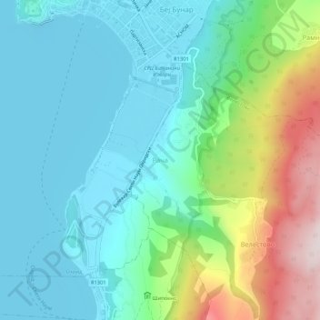
Name: Racha topographic map, elevation, terrain.
Location: Racha, Velestovo, Municipality of Ohrid, 6000, North Macedonia (41.07374 20.79202 41.11374 20.83202)
Average elevation: 838 m
Minimum elevation: 686 m
Maximum elevation: 1,284 m
Make a donation
Other topographic maps
Click on a map to view its topography, its elevation and its terrain.
Make a donation
Kratovo
Kratovo (Macedonian: Кратово [ˈkratɔvɔ] ) is a small town in North Macedonia. It is the seat of Kratovo Municipality. It lies on the western slopes of Mount Osogovo at an altitude of 600 metres (2,000 ft) above sea level. Having a mild and pleasant climate, it is located in the crater of an extinct…
Average elevation: 870 m
Make a donation
Bitola
Bitola is located in the southwestern part of North Macedonia. The Dragor River flows through the city. Bitola lies at an elevation of 615 metres above sea level, at the foot of Baba Mountain. Its magnificent Pelister mountain (2,601 m) is a national park with exquisite flora and fauna, among which is the…
Average elevation: 713 m
Make a donation
Make a donation
Make a donation
Make a donation
Make a donation
Make a donation
Make a donation
Ohrid
Ohrid is located in the south-western part of North Macedonia, on the shore of Lake Ohrid, at an elevation of 695 meters above sea level.
Average elevation: 901 m
Make a donation
Make a donation
Make a donation
Ohrid
Ohrid is located in the south-western part of North Macedonia, on the shore of Lake Ohrid, at an elevation of 695 meters above sea level.
Average elevation: 901 m
Make a donation
Ohrid
Ohrid is located in the south-western part of North Macedonia, on the shore of Lake Ohrid, at an elevation of 695 meters above sea level.
Average elevation: 901 m
Bitola
Bitola is located in the southwestern part of North Macedonia. The Dragor River flows through the city. Bitola lies at an elevation of 615 metres above sea level, at the foot of Baba Mountain. Its magnificent Pelister mountain (2,601 m) is a national park with exquisite flora and fauna, among which is the…
Average elevation: 713 m
Make a donation
Make a donation
Make a donation
Make a donation
Make a donation
Ohrid
Ohrid is located in the south-western part of North Macedonia, on the shore of Lake Ohrid, at an elevation of 695 meters above sea level.
Average elevation: 900 m
Make a donation
Bitola
Bitola is located in the southwestern part of North Macedonia. The Dragor River flows through the city. Bitola lies at an elevation of 615 metres above sea level, at the foot of Baba Mountain. Its magnificent Pelister mountain (2,601 m) is a national park with exquisite flora and fauna, among which is the…
Average elevation: 713 m
Make a donation