Geolocate

Irgertsheim topographic map

Interactive map

Click on the map to display elevation.

About this map

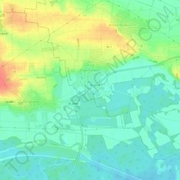
Name: Irgertsheim topographic map, elevation, terrain.

Location: Irgertsheim, West, Ingolstadt, Bayern, Deutschland (48.74601 11.25591 48.78166 11.31125)

Average elevation: 385 m

Minimum elevation: 365 m

Maximum elevation: 423 m

Other topographic maps

Click on a map to view its topography, its elevation and its terrain.

85049

Deutschland > Bayern > Ingolstadt

85049, West, Ingolstadt, Bayern, Deutschland

Average elevation: 377 m

Dünzlau

Deutschland > Bayern > Ingolstadt > Dünzlauer Mühle

Dünzlau, Dünzlauer Mühle, West, Ingolstadt, Bayern, 85049, Deutschland

Average elevation: 378 m

Niederfeld

Deutschland > Bayern > Ingolstadt

Niederfeld, Südost, Ingolstadt, Bayern, Deutschland

Average elevation: 365 m

Unterbrunnenreuth

Deutschland > Bayern > Ingolstadt

Unterbrunnenreuth, Süd, Ingolstadt, Bayern, Deutschland

Average elevation: 369 m

Zuchering

Deutschland > Bayern > Ingolstadt > Zuchering

Zuchering, Ingolstadt, Bayern, 85051, Deutschland

Average elevation: 370 m

Gerolfing Nord

Deutschland > Bayern > Ingolstadt > Gerolfing Nord

Gerolfing Nord, West, Ingolstadt, Bayern, 85049, Deutschland

Average elevation: 374 m

Richard-Strauss-Straße

Deutschland > Bayern > Ingolstadt

Richard-Strauss-Straße, Nordwest, Ingolstadt, Bayern, Deutschland

Average elevation: 377 m