
Andernach topographic map
Interactive map
Click on the map to display elevation.
About this map
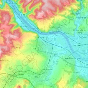
Name: Andernach topographic map, elevation, terrain.
Average elevation: 154 m
Minimum elevation: 52 m
Maximum elevation: 360 m
Other topographic maps
Click on a map to view its topography, its elevation and its terrain.
Mülheim-Kärlich
Deutschland > Rheinland-Pfalz > Landkreis Mayen-Koblenz
Mülheim-Kärlich, Weißenthurm, Landkreis Mayen-Koblenz, Rheinland-Pfalz, Deutschland
Average elevation: 112 m
Sankt Johann
Deutschland > Rheinland-Pfalz > Landkreis Mayen-Koblenz > Sankt Johann
Sankt Johann, Vordereifel, Landkreis Mayen-Koblenz, Rheinland-Pfalz, Deutschland
Average elevation: 394 m