
Landquart topographic map
Interactive map
Click on the map to display elevation.
About this map
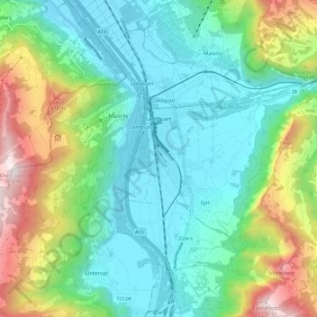
Name: Landquart topographic map, elevation, terrain.
Location: Landquart, Graubünden, Schweiz (46.93625 9.49835 46.97657 9.61162)
Average elevation: 856 m
Minimum elevation: 500 m
Maximum elevation: 1,783 m
Wer zu Fuss ins Prättigau gelangen will, schlägt ab dem Bahnhof den Weg zum Prättigauer Höhenweg ein, welcher der ganzen Rätikon-Kette entlangführt.
Other topographic maps
Click on a map to view its topography, its elevation and its terrain.
Mastrils
Schweiz > Graubünden > Landquart
Mastrils, Landquart, Graubünden, 7303, Schweiz
Average elevation: 910 m