
Red Rock topographic map
Interactive map
Click on the map to display elevation.
About this map
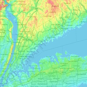
Name: Red Rock topographic map, elevation, terrain.
Location: Red Rock, Greenwich, Fairfield, Connecticut, 06876, USA (40.68621 -73.93179 41.32621 -73.29179)
Average elevation: 56 m
Minimum elevation: -6 m
Maximum elevation: 390 m
Other topographic maps
Click on a map to view its topography, its elevation and its terrain.
Greenwich Harbor
USA > Connecticut > Greenwich
Greenwich Harbor, Steamboat Road, Greenwich, Fairfield, Connecticut, 06830, USA
Average elevation: 14 m
Audubon Greenwich
USA > Connecticut > Greenwich
Audubon Greenwich, John Street, Greenwich, Fairfield, Connecticut, 10504:10506, USA
Average elevation: 132 m
Island Beach
USA > Connecticut > Greenwich
Island Beach, Greenwich, Fairfield, Connecticut, USA
Average elevation: 0 m