
Pantai Aceh topographic map
Interactive map
Click on the map to display elevation.
About this map
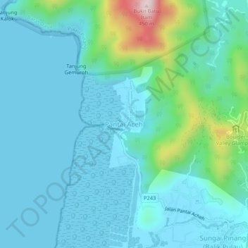
Name: Pantai Aceh topographic map, elevation, terrain.
Location: Pantai Aceh, Barat Daya, PNG, 11050, Malásia (5.39547 100.17635 5.43547 100.21635)
Average elevation: 73 m
Minimum elevation: -1 m
Maximum elevation: 456 m
Other topographic maps
Click on a map to view its topography, its elevation and its terrain.
Penang National Park
Malásia > PNG > Pantai Aceh
Penang National Park, Taman Negara Bukit Batu to United Hokkien Cemetary, Teluk Bahang, Pantai Aceh, Barat Daya, PNG, 11050, Malásia
Average elevation: 74 m