
Tecate topographic map
Interactive map
Click on the map to display elevation.
About this map
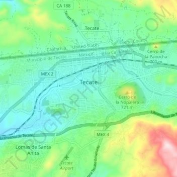
Name: Tecate topographic map, elevation, terrain.
Location: Tecate, Municipio de Tecate, Baja California, Mexico (32.54730 -116.66174 32.57921 -116.59162)
Average elevation: 595 m
Minimum elevation: 480 m
Maximum elevation: 920 m
Tecate's altitude of approximately 540 m (1,770 ft) above sea level and its proximity to the ocean contribute to the temperate climate. It rains enough in the area (almost 360 mm [14 in] per year) for a thick ground cover of shrubs and scattered trees to grow.
Other topographic maps
Click on a map to view its topography, its elevation and its terrain.
Palo Gacho
Mexico > Baja California > Municipio de Tecate
Palo Gacho, Municipio de Tecate, Baja California, Mexico
Average elevation: 1,382 m