
Thank you for supporting this site ❤️
Make a donation
Make a donation
Ghent topographic map
Click on the map to display elevation.
Thank you for supporting this site ❤️
Make a donation
Make a donation
About this map
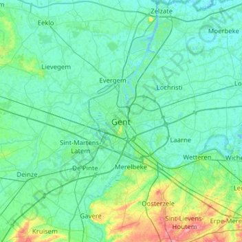
Name: Ghent topographic map, elevation, terrain.
Location: Ghent, Gent, East Flanders, Flanders, 24-32, Belgium (50.89383 3.56501 51.21383 3.88501)
Average elevation: 12 m
Minimum elevation: -3 m
Maximum elevation: 83 m
Thank you for supporting this site ❤️
Make a donation
Make a donation
Other topographic maps
Click on a map to view its topography, its elevation and its terrain.