
Make a donation
Invercargill City topographic map
Click on the map to display elevation.
Make a donation
About this map
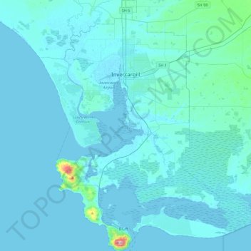
Name: Invercargill City topographic map, elevation, terrain.
Location: Invercargill City, Southland, New Zealand (-46.62559 168.19540 -46.32217 168.54278)
Average elevation: 11 m
Minimum elevation: -2 m
Maximum elevation: 236 m
Make a donation
Other topographic maps
Click on a map to view its topography, its elevation and its terrain.
Mitre Peak
New Zealand > Southland > Southland District > Fiordland Community
Average elevation: 657 m
Riverton
New Zealand > Southland > Southland District > Oraka Aparima Community
Average elevation: 16 m
Make a donation
Roslyn Bush
New Zealand > Southland > Southland District > Waihopai Toetoe Community
Average elevation: 29 m
Nightcaps
New Zealand > Southland > Southland District > Wallace Takitimu Community
Average elevation: 183 m
Make a donation
Clifden
New Zealand > Southland > Southland District > Tuatapere Te Waewae Community
Average elevation: 70 m
Edendale
New Zealand > Southland > Southland District > Waihopai Toetoe Community
Average elevation: 41 m
Pukemaori
New Zealand > Southland > Southland District > Tuatapere Te Waewae Community
Average elevation: 124 m
Make a donation
Makarewa Junction
New Zealand > Southland > Southland District > Oreti Community
Average elevation: 17 m
Make a donation
Otahu Flat
New Zealand > Southland > Southland District > Tuatapere Te Waewae Community
Average elevation: 90 m
Make a donation
Tūātapere
New Zealand > Southland > Southland District > Tuatapere Te Waewae Community
Average elevation: 41 m
Mount Tūtoko
New Zealand > Southland > Southland District > Fiordland Community
Average elevation: 1,892 m
Mount Anglem / Hananui
New Zealand > Southland > Southland District > Stewart Island / Rakiura Community
Mount Anglem / Hananui is the highest point on New Zealand's Stewart Island / Rakiura. It is located 20 kilometres (12 mi) northwest of Oban, close to the island's north coast, and rises to an elevation of 980 metres (3,215 ft) above sea level. Following the passage of the Ngāi Tahu Claims Settlement Act…
Average elevation: 668 m
Mount Christina
New Zealand > Southland > Southland District > Fiordland Community
Average elevation: 1,574 m
Make a donation
Takitimu Mountains
New Zealand > Southland > Southland District > Wallace Takitimu Community
Average elevation: 828 m
Te Puhi-a-noa / Murchison Mountains
New Zealand > Southland > Southland District
Average elevation: 851 m
Make a donation
Darran Mountains
New Zealand > Southland > Southland District > Fiordland Community
Average elevation: 911 m
Skippers Range
New Zealand > Southland > Southland District > Fiordland Community
Average elevation: 595 m
Te Rau / Garvie Mountains
New Zealand > Southland > Southland District > Cromwell Community
Average elevation: 1,393 m
Make a donation
Wick Mountains
New Zealand > Southland > Southland District > Fiordland Community
Average elevation: 1,185 m
Tapuae-o-Uenuku / Hector Mountains
New Zealand > Southland > Queenstown-Lakes District
The foothills of the Hector Mountains were also significant to early Pākehā. The range was largely affected by the Otago gold rush of the 1860s, which saw miners flock to the Nevis in search of gold and a small town established in the foothills of the range. Sluicing sites are found along the eastern end of…
Average elevation: 1,087 m
Make a donation
Mararoa River
New Zealand > Southland > Southland District > Fiordland Community
Average elevation: 681 m
Waikawa River
New Zealand > Southland > Southland District > Waihopai Toetoe Community
Average elevation: 134 m
Make a donation
Lake Quill
New Zealand > Southland > Southland District > Fiordland Community
Average elevation: 1,228 m
Lake Te Au
New Zealand > Southland > Southland District > Fiordland Community
Average elevation: 597 m
Age Glacier
New Zealand > Southland > Southland District > Fiordland Community
Average elevation: 1,753 m
Make a donation
Pembroke Glacier
New Zealand > Southland > Southland District > Fiordland Community
Average elevation: 1,211 m
Make a donation
Oban
New Zealand > Southland > Southland District > Stewart Island / Rakiura Community
Average elevation: 23 m
Mount Elliot
New Zealand > Southland > Southland District > Fiordland Community
Average elevation: 1,110 m
Waimānu / Stirling Falls
New Zealand > Southland > Southland District > Fiordland Community
Average elevation: 423 m
Make a donation
Nightcaps
New Zealand > Southland > Southland District > Wallace Takitimu Community
Average elevation: 183 m
Lake Innes
New Zealand > Southland > Southland District > Tuatapere Te Waewae Community
Average elevation: 223 m
Make a donation
Eldrig Peak
New Zealand > Southland > Southland District > Fiordland Community
Average elevation: 1,155 m
Oban
New Zealand > Southland > Southland District > Stewart Island / Rakiura Community
Average elevation: 23 m
Hineteawa / Bowen Falls
New Zealand > Southland > Southland District > Fiordland Community
Average elevation: 232 m
Make a donation
Island Hill
New Zealand > Southland > Southland District > Stewart Island / Rakiura Community
Average elevation: 50 m
Twin Sisters
New Zealand > Southland > Southland District > Fiordland Community
Average elevation: 1,039 m
Make a donation
Pearl Harbour
New Zealand > Southland > Southland District > Fiordland Community > Manapouri
Average elevation: 212 m
Make a donation
Merrivale
New Zealand > Southland > Southland District > Tuatapere Te Waewae Community
Average elevation: 192 m
Mount Owen
New Zealand > Southland > Southland District > Fiordland Community
Average elevation: 1,269 m
Sutherland Falls
New Zealand > Southland > Southland District > Fiordland Community
Average elevation: 1,006 m
Make a donation
Mitre Peak
New Zealand > Southland > Southland District > Fiordland Community
Average elevation: 657 m
White Peak
New Zealand > Southland > Southland District > Tuatapere Te Waewae Community
Average elevation: 1,153 m
Blackmount
New Zealand > Southland > Southland District > Tuatapere Te Waewae Community > Blackmount
Average elevation: 170 m
Make a donation
Waikawa
New Zealand > Southland > Southland District > Waihopai Toetoe Community > Waikawa
Average elevation: 39 m
Make a donation
Mount Makere
New Zealand > Southland > Southland District > Fiordland Community
Average elevation: 1,433 m
Turner Falls
New Zealand > Southland > Southland District > Fiordland Community
Average elevation: 1,335 m
The Downs
New Zealand > Southland > Southland District > Tuatapere Te Waewae Community
Average elevation: 34 m
Make a donation