
Make a donation
Bayreuth topographic map
Click on the map to display elevation.
Make a donation
Bayreuth
In most places there is a signed cycle path network. In the centre of Bayreuth itself, cycling is fairly straightforward due to the relatively flat topography, something which encourages the use bicycles as an everyday means of transport. Because of the proximity of the 600 kilometre long Main Cycleway, Bayreuth is also a destination for many tourist cycle routes. Because of the long service intervals of the Bayreuth town bus system and its long overnight pause, students use bicycles as their everyday mode of transport. Bicycles may be carried for a fee on DB Regio trains leaving Bayreuth and in the VGN's buses.
Make a donation
About this map
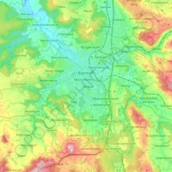
Name: Bayreuth topographic map, elevation, terrain.
Location: Bayreuth, Bavaria, Germany (49.88819 11.47512 49.97726 11.67283)
Average elevation: 410 m
Minimum elevation: 314 m
Maximum elevation: 593 m
Make a donation
Other topographic maps
Click on a map to view its topography, its elevation and its terrain.
Zugspitze
Germany > Bavaria > Landkreis Garmisch-Partenkirchen > Grainau
The mountain rises eleven kilometres southwest of Garmisch-Partenkirchen and just under six kilometres east of Ehrwald. The border between Germany and Austria runs over the west summit; thus the Zugspitze massif belongs to the German state of Bavaria and the Austrian state of Tyrol. The municipalities…
Average elevation: 2,300 m
Make a donation
Make a donation
Make a donation