
Zhangjiakou topographic map
Interactive map
Click on the map to display elevation.
About this map
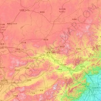
Name: Zhangjiakou topographic map, elevation, terrain.
Location: Zhangjiakou, Hebei, China (39.55116 113.81807 42.14716 116.45931)
Average elevation: 1,203 m
Minimum elevation: 21 m
Maximum elevation: 2,759 m
Um Tourismus aus anderen Regionen Chinas anzulocken strebt die Stadtregierung das Ziel an, Zhangjiakou zu einem nationalen Wintersportzentrum zu machen und wirbt um Investitionen in Höhe von 1 Milliarde US-Dollar für die Entwicklung des Saibei Skiing Resorts 塞北滑雪场 und des Hebei Cuiyunshan huaxuechang 河北翠云山滑雪场. Im Winter 2007 wurde das Skigebiet Saibei Dolomiti im Bezirk Chongli eröffnet. Zusammen mit dem Cuiyun Mountain Recreational Village Ski Resort, sind dort insgesamt zwei Kilometer Pisten verschiedener Schwierigkeitsgrade sowie acht Lifte mit einer Länge von insgesamt 3 Kilometern verfügbar.
Other topographic maps
Click on a map to view its topography, its elevation and its terrain.