
Thank you for supporting this site ❤️
Make a donation
Make a donation
Pollard topographic map
Click on the map to display elevation.
Thank you for supporting this site ❤️
Make a donation
Make a donation
About this map
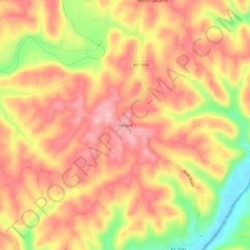
Name: Pollard topographic map, elevation, terrain.
Location: Pollard, Jessamine County, Kentucky, United States (37.78675 -84.52994 37.82675 -84.48994)
Average elevation: 259 m
Minimum elevation: 166 m
Maximum elevation: 310 m
Thank you for supporting this site ❤️
Make a donation
Make a donation
Other topographic maps
Click on a map to view its topography, its elevation and its terrain.