
Thank you for supporting this site ❤️
Make a donation
Make a donation
Pendling topographic map
Click on the map to display elevation.
Thank you for supporting this site ❤️
Make a donation
Make a donation
About this map
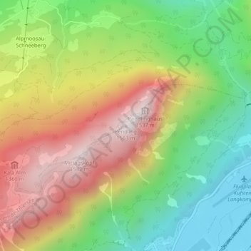
Name: Pendling topographic map, elevation, terrain.
Location: Pendling, Thiersee, Bezirk Kufstein, Tirol, 6335, Österreich (47.57120 12.10897 47.57130 12.10907)
Average elevation: 960 m
Minimum elevation: 479 m
Maximum elevation: 1,540 m
Thank you for supporting this site ❤️
Make a donation
Make a donation