
Thank you for supporting this site ❤️
Make a donation
Make a donation
Jayapura topographic map
Click on the map to display elevation.
Thank you for supporting this site ❤️
Make a donation
Make a donation
Jayapura
The topography of Jayapura varies from valleys to hills, plateaus, and mountains up to 700 metres (2,300 ft) above sea level. Jayapura overlooks the Yos Sudarso Bay. Jayapura is about 94,000 hectares (230,000 acres) in area, and is divided into five districts. Around 30% of the area is inhabited, with the remainder consisting of a rough terrain, swamps, and protected forest.
Thank you for supporting this site ❤️
Make a donation
Make a donation
About this map
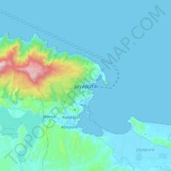
Name: Jayapura topographic map, elevation, terrain.
Location: Jayapura, Papua, 99111, Indonesia (-2.69875 140.54374 -2.37875 140.86374)
Average elevation: 149 m
Minimum elevation: 0 m
Maximum elevation: 1,660 m
Thank you for supporting this site ❤️
Make a donation
Make a donation