
Thank you for supporting this site ❤️
Make a donation
Make a donation
Caldera topographic map
Click on the map to display elevation.
Thank you for supporting this site ❤️
Make a donation
Make a donation
About this map
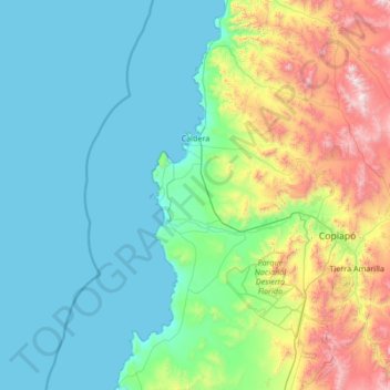
Name: Caldera topographic map, elevation, terrain.
Location: Caldera, Provincia de Copiapó, Atacama Region, Chile (-27.83756 -70.97690 -26.64312 -70.24548)
Average elevation: 374 m
Minimum elevation: 0 m
Maximum elevation: 2,041 m
Thank you for supporting this site ❤️
Make a donation
Make a donation
Other topographic maps
Click on a map to view its topography, its elevation and its terrain.
Bahía Inglesa
Chile > Atacama Region > Provincia de Copiapó > Caldera
Bahia Inglesa ("English Bay") is a locality located near the port of Caldera in Atacama Region, Chile. It is situated at an average elevation of 10 meters above the sea level. As of 2017, it had a population of 535.
Average elevation: 10 m