
Kampar topographic map
Interactive map
Click on the map to display elevation.
About this map
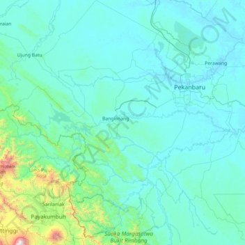
Name: Kampar topographic map, elevation, terrain.
Location: Kampar, Riau, Sumatra, Indonésie (-0.38923 100.42931 1.02991 101.68740)
Average elevation: 174 m
Minimum elevation: 2 m
Maximum elevation: 2,855 m
Other topographic maps
Click on a map to view its topography, its elevation and its terrain.
Tanah Datar
Indonésie > Riau > Rokan Hulu
Tanah Datar, Kecamatan Kunto Darussalam, Rokan Hulu, Riau, Sumatra, Indonésie
Average elevation: 40 m
Kecamatan Pangkalan Kerinci
Kecamatan Pangkalan Kerinci, Kabupaten Pelalawan, Riau, Indonésie
Average elevation: 14 m
Tanah Datar
Indonésie > Riau > Tanah Datar
Tanah Datar, Kecamatan Rengat Barat, Kabupaten Indragiri Hulu, Riau, Indonésie
Average elevation: 56 m
Pangkalan Kerinci
Indonésie > Riau > Pangkalan Kerinci
Pangkalan Kerinci, Kabupaten Pelalawan, Riau, Indonésie
Average elevation: 9 m