Geolocate

Foncine-le-Haut topographic map

Interactive map

Click on the map to display elevation.

About this map

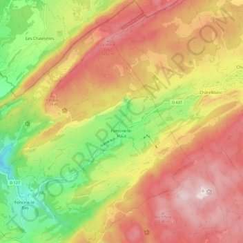
Name: Foncine-le-Haut topographic map, elevation, terrain.

Location: Foncine-le-Haut, Lons-le-Saunier, Jura, Burgund und Freigrafschaft, Metropolitanes Frankreich, 39460, Frankreich (46.62509 6.01609 46.70138 6.10646)

Average elevation: 1,027 m

Minimum elevation: 735 m

Maximum elevation: 1,276 m

Foncine-le-Haut liegt auf 860 m, etwa 16 Kilometer südöstlich der Stadt Champagnole (Luftlinie). Das Dorf erstreckt sich im Jura, in einem offenen Talbecken an der Mündung des Brideau in die Saine, zwischen den Waldhöhen von Haute Joux im Norden und Mont Noir im Süden.

Wikipedia (CC-BY-SA 3.0)

Other topographic maps

Click on a map to view its topography, its elevation and its terrain.

Bois-d'Amont

Frankreich > Burgund und Freigrafschaft > Jura

Bois-d'Amont, Saint-Claude, Jura, Burgund und Freigrafschaft, Metropolitanes Frankreich, 39220, Frankreich

Average elevation: 1,204 m

Doucier

Frankreich > Burgund und Freigrafschaft > Jura

Doucier, Lons-le-Saunier, Jura, Burgund und Freigrafschaft, Metropolitanes Frankreich, 39130, Frankreich

Average elevation: 549 m

Lamoura

Frankreich > Burgund und Freigrafschaft > Jura

Lamoura, Saint-Claude, Jura, Burgund und Freigrafschaft, Metropolitanes Frankreich, 39310, Frankreich

Average elevation: 1,147 m