
Beaumaris topographic map
Interactive map
Click on the map to display elevation.
About this map
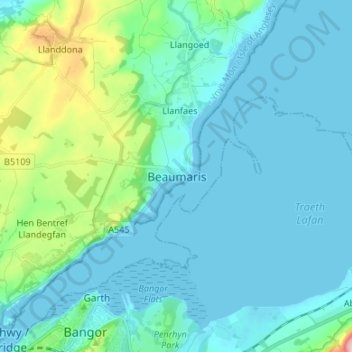
Name: Beaumaris topographic map, elevation, terrain.
Location: Beaumaris, Isle of Anglesey, Wales, LL58 8BP, United Kingdom (53.22300 -4.13216 53.30300 -4.05216)
Average elevation: 37 m
Minimum elevation: -1 m
Maximum elevation: 247 m
Other topographic maps
Click on a map to view its topography, its elevation and its terrain.
Beaumaris Castle
United Kingdom > Wales > Beaumaris
Beaumaris Castle, Castle Street, Beaumaris, Isle of Anglesey, Wales, LL58 8DA, United Kingdom
Average elevation: 22 m