
Tavropos (Megdova) topographic map
Interactive map
Click on the map to display elevation.
About this map
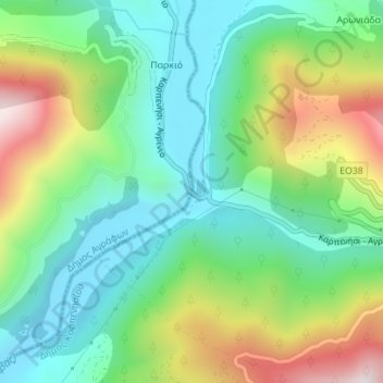
Name: Tavropos (Megdova) topographic map, elevation, terrain.
Average elevation: 494 m
Minimum elevation: 278 m
Maximum elevation: 922 m
Other topographic maps
Click on a map to view its topography, its elevation and its terrain.
Tavropos (Megdova)
Griechenland > Thessalien - Mittelgriechenland > Regionalbezirk Evrytania > Δημοτική Ενότητα Καρπενησίου
Tavropos (Megdova), Κ. Στενώματος, Δημοτική Ενότητα Καρπενησίου, Δήμος Καρπενησίου, Regionalbezirk Evrytania, Region Mittelgriechenland, Thessalien - Mittelgriechenland, Griechenland
Average elevation: 497 m
Tavropos (Megdova)
Griechenland > Thessalien - Mittelgriechenland > Regionalbezirk Evrytania
Tavropos (Megdova), Κ. Βράχας, Δήμος Καρπενησίου, Regionalbezirk Evrytania, Region Mittelgriechenland, Thessalien - Mittelgriechenland, Griechenland
Average elevation: 694 m