
Hirzenhain topographic map
Interactive map
Click on the map to display elevation.
About this map
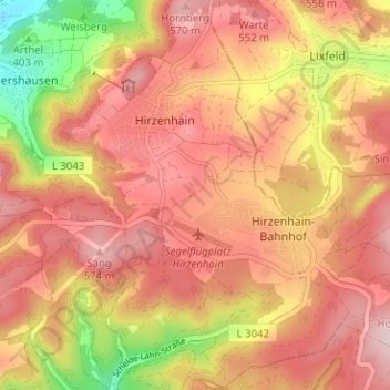
Name: Hirzenhain topographic map, elevation, terrain.
Location: Hirzenhain, Eschenburg, Lahn-Dill-Kreis, Hessen, Deutschland (50.77227 8.36966 50.81163 8.43281)
Average elevation: 490 m
Minimum elevation: 322 m
Maximum elevation: 585 m
Other topographic maps
Click on a map to view its topography, its elevation and its terrain.
Eibelshausen
Deutschland > Hessen > Lahn-Dill-Kreis > Eschenburg
Eibelshausen, Eschenburg, Lahn-Dill-Kreis, Hessen, 35713, Deutschland
Average elevation: 379 m