
Make a donation
Rovigo topographic map
Click on the map to display elevation.
Make a donation
Rovigo
The province of Rovigo corresponds with or is full included into contemporary Polesine. It has an area of 1,789 square kilometres (691 sq mi) and a total population of 244,625 inhabitants (2005). It is a plain whose elevation is from −2 to 15 metres (−7 to 49 ft).
Make a donation
About this map
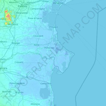
Name: Rovigo topographic map, elevation, terrain.
Location: Rovigo, Veneto, Italy (44.79243 11.17355 45.16195 12.55344)
Average elevation: 3 m
Minimum elevation: -7 m
Maximum elevation: 573 m
Make a donation
Other topographic maps
Click on a map to view its topography, its elevation and its terrain.
Tre Cime di Lavaredo - Drei Zinnen
Italy > Veneto > Belluno > Auronzo di Cadore
Until 1919 the peaks formed part of the border between Italy and Austria-Hungary. Now they lie on the border between the Italian provinces of South Tyrol and Belluno and still are a part of the linguistic boundary between German-speaking and Italian-speaking majorities. The Cima Grande has an elevation of…
Average elevation: 2,242 m
Make a donation
Make a donation