
Thank you for supporting this site ❤️
Make a donation
Make a donation
West Bath topographic map
Click on the map to display elevation.
Thank you for supporting this site ❤️
Make a donation
Make a donation
About this map
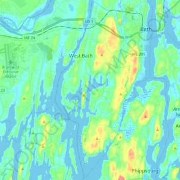
Name: West Bath topographic map, elevation, terrain.
Location: West Bath, Sagadahoc County, Maine, United States (43.81448 -69.89601 43.93159 -69.82855)
Average elevation: 15 m
Minimum elevation: -3 m
Maximum elevation: 80 m
Thank you for supporting this site ❤️
Make a donation
Make a donation
Other topographic maps
Click on a map to view its topography, its elevation and its terrain.