
الزعرور topographic map
Interactive map
Click on the map to display elevation.
About this map
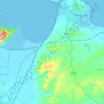
Name: الزعرور topographic map, elevation, terrain.
Location: الزعرور, معتمدية تينجة, Bizerte, Tunisia (37.07196 9.61516 37.14289 9.77940)
Average elevation: 48 m
Minimum elevation: -6 m
Maximum elevation: 434 m
Other topographic maps
Click on a map to view its topography, its elevation and its terrain.
Sidi Mechreg
Sidi Mechreg, سيدي مشرق, معتمدية سجنان, Bizerte, Tunisia
Average elevation: 46 m
Ras Jebel
Tunisia > Bizerte > رأس الجبل الشمالية
Ras Jebel, رأس الجبل الشمالية, معتمدية رأس الجبل, Bizerte, 7070, Tunisia
Average elevation: 62 m