
Thank you for supporting this site ❤️
Make a donation
Make a donation
Sultan Bathery topographic map
Click on the map to display elevation.
Thank you for supporting this site ❤️
Make a donation
Make a donation
Sultan Bathery
Sulthan Bathery is located at 11°40′N 76°17′E / 11.67°N 76.28°E / 11.67; 76.28. It has an average elevation of 907 m (2,976 ft).
Thank you for supporting this site ❤️
Make a donation
Make a donation
About this map
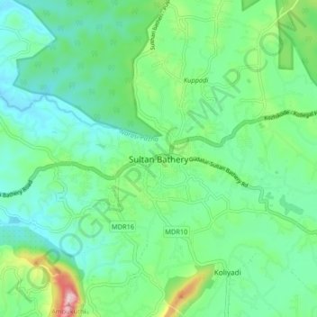
Name: Sultan Bathery topographic map, elevation, terrain.
Location: Sultan Bathery, Sulthanbathery, Wayanad, Kerala, 673592, India (11.62319 76.21955 11.70319 76.29955)
Average elevation: 876 m
Minimum elevation: 776 m
Maximum elevation: 1,185 m
Thank you for supporting this site ❤️
Make a donation
Make a donation
Other topographic maps
Click on a map to view its topography, its elevation and its terrain.
Thank you for supporting this site ❤️
Make a donation
Make a donation
Thank you for supporting this site ❤️
Make a donation
Make a donation