
Thank you for supporting this site ❤️
Make a donation
Make a donation
Lower Austria topographic map
Click on the map to display elevation.
Thank you for supporting this site ❤️
Make a donation
Make a donation
About this map
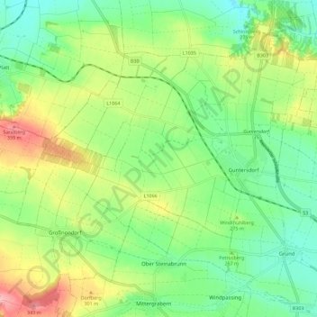
Name: Lower Austria topographic map, elevation, terrain.
Location: Lower Austria, 2042, Austria (48.62182 15.96783 48.68126 16.08032)
Average elevation: 265 m
Minimum elevation: 216 m
Maximum elevation: 349 m
Thank you for supporting this site ❤️
Make a donation
Make a donation
Other topographic maps
Click on a map to view its topography, its elevation and its terrain.
Kleinwolfstein
Austria > Lower Austria > Bezirk Amstetten > Neustadtl an der Donau
Average elevation: 364 m
Schenkenbrunn
Austria > Lower Austria > Bezirk Krems > Bergern im Dunkelsteinerwald
Average elevation: 511 m
Thank you for supporting this site ❤️
Make a donation
Make a donation
Poysdorf
Austria > Lower Austria > Bezirk Mistelbach > Gemeinde Poysdorf > Poysdorf
Average elevation: 246 m