
Sarria topographic map
Interactive map
Click on the map to display elevation.
About this map
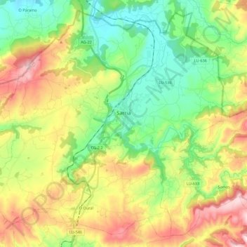
Name: Sarria topographic map, elevation, terrain.
Location: Sarria, Lugo, Galice, Espagne (42.69838 -7.54410 42.84429 -7.32723)
Average elevation: 568 m
Minimum elevation: 368 m
Maximum elevation: 891 m
Other topographic maps
Click on a map to view its topography, its elevation and its terrain.
Agra de Celeiro
Espagne > Galice > Sarria > Sarria
Agra de Celeiro, Sarria, Lugo, Galice, 27600, Espagne
Average elevation: 485 m
Ramil
Espagne > Galice > Sarria > Triacastela
Ramil, Triacastela, Sarria, Lugo, Galice, 27632, Espagne
Average elevation: 801 m