
Make a donation
Roanoke topographic map
Click on the map to display elevation.
Make a donation
Roanoke
Though located along the Blue Ridge Mountains at elevations exceeding 900 ft (270 m), Roanoke lies in the humid subtropical climate zone (Köppen Cfa), with four distinct, but generally mild, seasons; it is located in USDA hardiness zone 7b, with the suburbs falling in zone 7a. Extremes in temperature have ranged from 105 °F (41 °C) as recently as August 21, 1983, down to −12 °F (−24 °C) on December 30, 1917, though neither 100 °F (38 °C) nor 0 °F (−18 °C) is reached in most years; the most recent occurrence of each is July 8, 2012 and February 20, 2015. More typically, the area records an average of 6.1 days where the temperature stays at or below freezing and 30.5 days with 90 °F (32 °C)+ highs annually. The normal monthly mean temperature ranges from 37.9 °F (3.3 °C) in January to 77.8 °F (25.4 °C) in July.
Make a donation
About this map
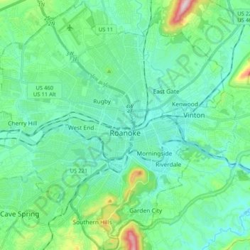
Name: Roanoke topographic map, elevation, terrain.
Location: Roanoke, Virginia, United States (37.21190 -80.03748 37.33761 -79.87855)
Average elevation: 333 m
Minimum elevation: 251 m
Maximum elevation: 680 m
Make a donation