
Thank you for supporting this site ❤️
Make a donation
Make a donation
Ashendon topographic map
Click on the map to display elevation.
Thank you for supporting this site ❤️
Make a donation
Make a donation
About this map
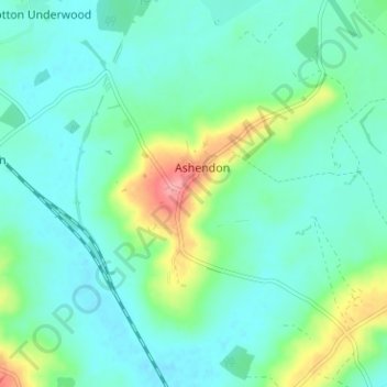
Name: Ashendon topographic map, elevation, terrain.
Location: Ashendon, Buckinghamshire, England, United Kingdom (51.80061 -1.00064 51.83962 -0.94689)
Average elevation: 88 m
Minimum elevation: 67 m
Maximum elevation: 156 m
Thank you for supporting this site ❤️
Make a donation
Make a donation
Other topographic maps
Click on a map to view its topography, its elevation and its terrain.
Thank you for supporting this site ❤️
Make a donation
Make a donation
Thank you for supporting this site ❤️
Make a donation
Make a donation